Abstract
San Juan Island and the town of Friday Harbor are abuzz with tourists during the summer, with backpackers and visitors swarming the downtown with every ferry arrival. Many come to see the two parks that were encampments for British and American soldiers in the 1860s during the “Pig War”. But Friday Harbor also has a lively nightlife, with a brew-pub, several restaurants and a harbor area that is lively with socializing boaters. And during the day it’s a center for cyclists, kayakers, divers and whale watchers.
History
The Pig War
In December 1853, Hudson’s Bay Company would move a group of settlers and sheep to San Juan Island to help support its claim that the island was British territory. Americans would respond immediately, sending tax collectors to the island but failing to collect anything. One of the settlers was a Hawaiian native, Joseph Poalie, nicknamed Joe Friday, who raised sheep in the “New Station” settlement that would become Friday Harbor.
 |
|
View of Friday Harbor from an arriving ferry
|
Colonial officials would threaten to arrest Cutlar and American settlers appealed to military officers for support. By July 27, Capt. George E. Pickett would land with 66 men and within two weeks he would have an additional 100 reinforcements. While British naval commanders would balk at starting a war over a pig, three warships were brought into the area.
The Americans located 14 cannon among earthen structures at what is now American Camp. The earth redoubt was built by Lt. Henry Martyn Roberts, an Army engineer who would later become famous for writing “Roberts Rules of Order” for parliamentary meetings.
President Buchanan would send Gen. Winfield Scott to contain the conflict and by November, 1859 Scott would negotiate a temporary agreement with James Douglas, governor of the Crown Colony of British Columbia. Both sides would withdraw reinforcements and the British could keep a warship in Griffin Bay under a joint military occupation. The English would not put soldiers ashore at what is now English Camp in Westcott Bay on the northwest corner of the island until March, 1860.
The dispute would take a back burner to the American Civil War and not be settled until 1871, when Kaiser Wilhelm of Germany arbitrated the border as Haro Strait, between San Juan Island and Vancouver Island.
George Pickett would go on the fame leading the fatal charge at Gettysburg during the third day of that battle. HBC would leave behind the main north-south road across the island that is now Military Road. Its Belle Vue Farm was adjacent to American Camp at the south end of the island and Charles Griffin’s name stays attached to the bay just east of American Camp.
Roche Harbor development
Limestone deposits on the northwest corner of San Juan Island were once part of the ocean floor but were gradually lifted above sea level as the islands’ tectonic plate crashed into the west coast of the American continent. The first residents to use the limestone to create concrete were English soldiers stationed at English Camp during the 1860s. Other settlers, including Lyman Cutlar, would also attempt to exploit the deposits around Lime Kiln Point.
Industrial development of the lime would come after John S. McMillin purchased the land around Roche Harbor and started the Tacoma and Roche Harbor Lime Co. in 1886. McMillin would become one of the richest Americans of his time, building a fleet of ships to carry the lime to ports as far away as San Francisco and building the Hotel de Haro on the site of the old Hudson Bay Co. trading post. At its peak McMillin’s company would employ 800 people.
The hotel remains, as does McMillin, whose remains are buried in a nearby mausoleum a short hike from the docks.
Places to visit
Friday Harbor
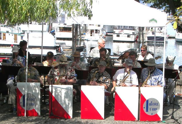 |
|
Band at the marina
|
The San Juan Historical Museum is at 405 Price Street, not too far from the airport. And you won’t have much trouble spotting the airport, as prevailing winds have airplanes landing over the town most of the time. Friday Harbor was the home of aviation author Ernest Gann (“The High and the Mighty” and “Fate is the Hunter”) until his death in 1991. The café at the airport is “Ernie’s Café” and it has mementos of his career.
American Camp
- You can stop on the east side of the airport and watch planes land from a viewpoint above the runway.
- You will see Griffin Bay and the San Juan Channel the way the Hudson Bay Co. settlers did from Belle Vue Farm.
- Turtleback Mountain on Orcas Island takes on its turtle shape from viewpoints near American Camp.
- Arriving at American Camp you’ll see the Straits of San Juan de Fuca before you, Victoria to the west, and on a clear day Port Angeles to the south (at the base of the Olympic Mountains).
- American Camp itself overlooks the kelp beds at the south end of the island. The kelp attracts salmon and the salmon attract Orca whales but you’ll need binoculars to see any marine mammals.
- You may see golden fox patrolling the hillsides hunting for rabbits or deer grazing on the grass prairies.
American Camp has an interpretive center near the site of what were once the base barracks. The National Park Service’s “American Camp: A Historic Guided Walk” is an excellent overview.
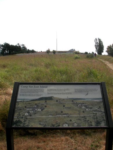 |
|
American Camp
|
This portion of the island is sunny and dry, getting less than half the annual rainfall of British camp, only 10 miles away. Southeastern San Juan Island and Cattle Point lie in the Olympic Mountain rain shadow. It makes it an excellent place to picnic.
The area on both sides of Cattle Point Road are part of the park. Trails run down to Jakles Lagoon on Griffin Bay but make sure that you take water, as the hikes can be hot and dry. A road also runs down to the beach from an access road about ½ mile past the interpretive center.
Cattle Point
 |
|
Cattle Pass and Cattle Point Lighthouse, built in 1935
|
False Bay
 |
|
False Bay, looking south into the Straits of San Juan de Fuca
|
Access off Cattle Point Road is on False Bay Drive, which runs west. A short portion of the road is a gravel road that is maintained enough to be useable by cyclists.
English Camp
On the northwest corner of the island, just south of Roche Harbor, this location couldn’t be more different from the grass prairies of American Camp. Because of its location along the Olympic Mountain rain shadow, it receives about twice the annual rainfall. The British soldiers stationed here planted lush English gardens in a site surrounded by tall Douglas fir trees.
 |
|
English Camp, 1870. The blockhouse remains today (under the flag), as does the commissary building behind it
|
English Camp is about 10 miles from the ferry. The quickest way to get there is past Friday Harbor High School along Roche Harbor Road. After eight miles you’ll come to West Valley Road, then go south about 1.5 miles.
But don’t do the trip too quickly or you’ll miss the farm with a camel on the south side of Roche Harbor Road. Or the San Juan Vineyards on the north side.
The barracks, gardens and wharf at English Camp are all along Westcott Bay in an area that’s easy enough to reach that there is wheelchair access. Less visited is the portion of the park that is just east of the West Valley Road, where trails lead up to Young Hill, 650’ above sea level. The small cemetery for the British encampment (population: 7) is located along the trail.
Most of San Juan Island is a good place to bike, including all of the way to English Camp (and north to Roche Harbor). However, the West Valley and Mitchell Bay roads south of English camp are narrow, shaded, hilly and curvy, making caution necessary.
Roche Harbor
More than any other location in the San Juans, Roche Harbor is likely to remind visitors from the northeast of the coast of Maine. It has beautiful old wooden buildings surrounding a well-enclosed harbor; tall trees on the hills nearby; and scarcely a yacht under 40’ long.
 |
|
Lime kilns adjacent to new developments at Roche Harbor
|
In the marina there’s a café for casual dining as well as McMillin’s Dining Room for fine dining.
Also, coming into Roche Harbor you’ll also pass through the Westcott Bay Sculpture Park opposite the Roche Harbor Airport.
If you’re flying into the Roche Harbor airport and it looks like you’re landing on the road, it is because a portion of the runway once was the road to Roche Harbor.
As with the trip to English Camp, you get to the village along the Roche Harbor Road, but the resort is north on at the West Valley intersection for another 1.4 miles.
Finally, if you’d like to visit an oyster farm, you can stop on the way into Roche Harbor at Westcott Bay Sea Farms. Their oysters are served at restaurants through western Washington.
Lime Kiln Point State Park
On the west side of the island is Lime Kiln Point, which looks out onto Victoria, BC across the Haro Strait. During the day it is popular with whale watchers, as salmon tend to run through kelp beds along the south and west sides of the island, bringing whales. Orcas are the largest and most-visible (bring the binoculars here too) but you’re equally likely to see Minke whales, which are small and often confused with dolphins or porpoises. At sunset this park is highly popular.
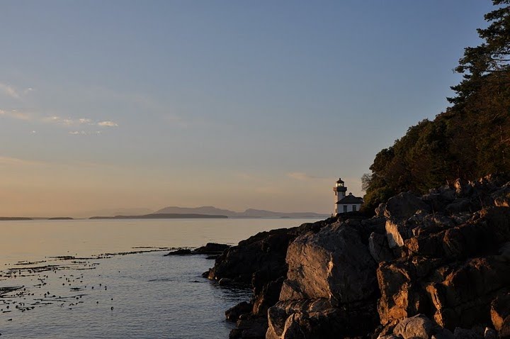 |
|
Lighthouse at Lime Kiln Point at sunset
|
On the way to Lime Kiln Park you may want to stop at Pelindaba Lavender Farm, also called the Pi Farm. Pelindaba, which commercializes a variety of lavender products, has a large collection of stainless steel sculptures done by Micajah Bienvenue, including the large Greek letter Pi. The farm is on Wold Road opposite a large lake, ½ mile north of Bailer Hill Road. Pelindaba also has a retail store on 1st Street in Friday Harbor.
Festivals and fairs
http://depts.washington.edu/fhl/events.html
http://www.thesanjuans.com/sanjuan-general/san-juan-island-pig-war.shtml
http://www.sanjuancountyfair.org/
How to get there
The Washington state ferry system is the public highway for the islands, leaving Anacortes for Shaw, Lopez, Orcas and San Juan islands. In addition, one ferry a day makes the trip to Vancouver Island. Passengers (and vehicles) pay only for the west-bound trip.
Schedules change for each season. Reservations are taken ONLY for the international ferry to Vancouver Island. During non-peak hours, passengers often arrive 30 minutes before sailing but it is wise to check the Anacortes terminal website or one of the ferrycams operated by the state to see if lines are longer, which they often are on weekends. Parking is also available at Anacortes for walk-on and bike passengers.
The Victoria Clipper, a high-speed catamaran, also serves the islands with passenger only service from downtown Seattle. Kenmore Air is a float plane service that provides air transportation between Seattle and three of the largest islands. San Juan Airlines also operates Cessna Stationair planes to the airports at Friday Harbor, Lopez Island, Eastsound (on Orcas Island) and Roche Harbor.
There are taxis on San Juan Island as well as a private bus system that services the major resorts.
Dining and Accommodations
Lodging
There is no shortage of state, county and national parks on this island but public camping is in short supply. San Juan County manages the public camping slots at the county park on the west side (at Smallpox Bay) through a reservation system.
Private camping is available at Lakedale Resort at the north side, halfway between Friday Harbor and Roche Harbor. The resort has cabins, tent cabins and plain old camping spots, along with full facilities and trout fishing in the lake.
On the west side, Snug Harbor Resort (just south of English Camp) offers camping and a variety of other outdoor activities.
As with all of the San Juan chain, bed & breakfast options are plentiful. One that is unique to Friday Harbor is the Wharfside B&B aboard the 60’ wooden ship, Slow Season. The host and hostess are a retired Austrian couple.
Finally there’s no shortage of hotels in Friday Harbor – and let us not forget Roche Harbor either.
Friday Harbor Suites
http://www.fridayharborsuites.com/
Roche Harbor Resort
http://www.rocheharbor.com/lodging_overview.html
Friday Harbor House
http://www.fridayharborhouse.com/index.php
Restaurants
Downrigger’s is located directly across the street from San Juan Brewing on Front Street. In warm weather this sea food restaurant doubles its capacity with an open deck over the harbor.
(360) 378-2700
http://www.downriggerssanjuan.com/
 |
|
McMillin’s Dining Room at Roche Harbor
|
(360) 378-8455
http://www.rocheharbor.com/dining_mcmillins.html
Nearby attractions
The international ferry also connects Friday Harbor to Victoria, BC once each day. Note that reservations are recommended for vehicle traffic and passports or other secured IDs are required for all passengers. Oh, and don’t mistakenly get on the international ferry on the way back to Anacortes (like I once did with a French visitor that I’d told not to bother bringing a passport) because you’ll still have to clear customs, even if you’re coming from one of the U.S. islands.
References
http://www.mountaineersbooks.org/productdetails.cfm?PC=1244
http://www.historylink.org/index.cfm?DisplayPage=output.cfm&file_id=7505
http://www.nps.gov/archive/sajh/Belle_Vue_Sheep_Farm.htm
http://www.nps.gov/archive/sajh/Pig_War_new.htm
http://www.nps.gov/sajh/historyculture/the-pig-war.htm
http://www.nps.gov/history/history/online_books/sajh1/hrs.pdf
http://www.rocheharbor.com/aboutus_history.html
